
So, you want to trim or remove a tree, but you need to check if you can? Luckily, we’re here to help.
Our clients have often said that dealing with Auckland Council isn’t often a fun process. Even if you do figure out how to use the GIS Viewer, what does everything mean? What layers do you need to include to make sure you’re not missing anything? How do you stay out of trouble?
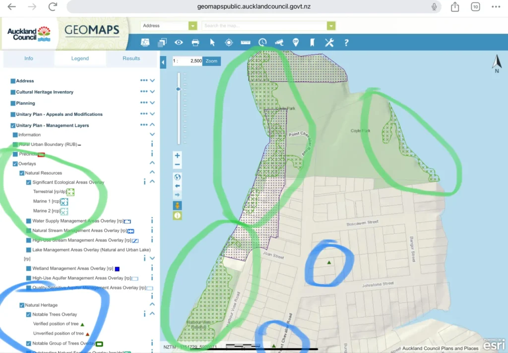
As an example, there are some interesting tree controls at the end of Point Chevalier, including along the beach. What makes this an interesting example is that it’s not just your classic ‘Notable Tree’ restrictions, but also listed as a Significant Ecological Area (SEA), as well as under Mana Whenua protection too!
Wow, that’s a lot huh. But why does the council care so much?
A tree has been put on that list for a reason, and deserves respect. Here is a breakdown of why:
What is a Notable Tree?
A Notable tree is a bit of a big deal in high tree society. It’s usually been there ages, or it has historical importance. Our personal lives are a blip in the timescale of New Zealand ecology, which dates back to the dinosaurs. Any trimming of a Notable tree needs to be done to maintain the health and structure of the tree. There are limitations on how much you can prune these, which without understanding their importance, can seem a bit arbor-trary (see what I did there?).
If these restrictions aren’t practical for your, or for the tree’s needs, we can apply to council to obtain consent to do this required additional work.
What are Significant Ecological Areas (SEA’s)?
A Significant Ecological Area is also an important definition, as it’s areas like these that make Auckland so beautiful. The purpose of SEA’s is to protect and maintain indigenous biodiversity, and Auckland Council’s definitions for ecologically important areas are defined as meeting at least one of the following criteria:
- Representativeness
- Threat status and/or rarity
- Diversity
- Stepping stones, migration pathways and buffers.
- Uniqueness or distinctiveness.
Although any work undertaken in an SEA requires extra consideration, there are reasonable things you can do, including:
- Biosecurity tree work.
- Deadwood removal.
- Vegetation alteration or removal for routine maintenance and repair of existing tracks, lawns, gardens, fences and other lawfully established activities.
- Vegetation alteration or removal for customary use.
- Emergency tree works where property/people are at immediate risk.
- Pest plant removal.
- Conservation planting.
- Vegetation alteration or removal for routine maintenance within 3m of the existing dwelling.
- Vegetation alteration or removal for routine maintenance within 3m of existing buildings greater than 100m2 gross floor area.
Our advice is to ask first, before starting work. And if you do need to get resource consent, so be it.
Mana Whenua – Sites and Places of Significance to Mana Whenua
Mana Whenua areas are also an extremely important consideration. Whether we are Tangata Whenua or Tangata Tiriti, we all need to respect the unique history of Aotearoa, and to continue to act as guardians of this land. The reason why I chose Point Chevalier as an example here, is because it has an interesting history that isn’t well known, but is worth knowing for this context.
Point Chevalier Primary school is named after Point Chev’s original name of Rangi-Mata-Rau, which roughly translates to ‘the day of a hundred spears’. How did it come to have such an epic, yet foreboding name in the first place?
Well, that’s kind of the entire point. I’ll try explain why the Mana Whenua protection areas actually matter.
Modern day Point Chevalier is hot property, known for its proximity to town, its community, relative quietness for an inner city suburb because it’s its own peninsula. That and its awesome inner city beach, and the Meola Reef dog park. Back in the (pre-colononisation) days, it was no different. As an Iwi settlement, it was valued as a highly productive fishing spot, with fish, shark and even stingrays found in the shallows. The land was productive (if not a little boggy). This, combined with the strategic advantages such as walking proximity to other settlements, a sheltered bay for waka whilst being on the doorstep of the Waitamata, and the mouth of the Whau river – which by the way was used to migrate waka up through what is now New Lynn, then up and over to Blockhouse Bay Beach, to reach the Manukau. Just up the coastline, Oakley Creek has Mana Whenua protection for the same reason.
Prime real estate comes at a premium, and for the Iwi that inhabited Rangi-mata-rau, that premium was paid in defending their settlement. The actual historical events of the area are still under discussion and not on ‘official’ record. However, according to the Auckland Council, there is specific legend recorded of a huge inter Iwi battle that happened. This is where the Māori name ‘battle of a hundred spears’ or Rangi-mata-rau came from, set in motion because of a marriage between a Ngati-hoa chief and a bride from Ngati-Paoa iwi. Along the beachfront of Point Chevalier, there are archeological records of this battle.
Areas under Mana Whenua protection are important, and deserve to be celebrated as such.
As arborists, we take all of this into account as we believe in the practice of guardianship. The green spaces of Auckland are something we all benefit from, and it is an honour to care for trees that will still be around for generations to come.
Thanks for coming to my TED talk, now back to what you actually came here for:
Here’s a screenshot to highlight these details on the GIS viewer:
Using the Council GIS Viewer
The bureaucratic monster that is the Council can be tricky to navigate, so we’ve made an easy, step by step process for you to follow.
A) Jump on the Auckland Council GIS Viewer here
B) Click the OpenGeoMaps button
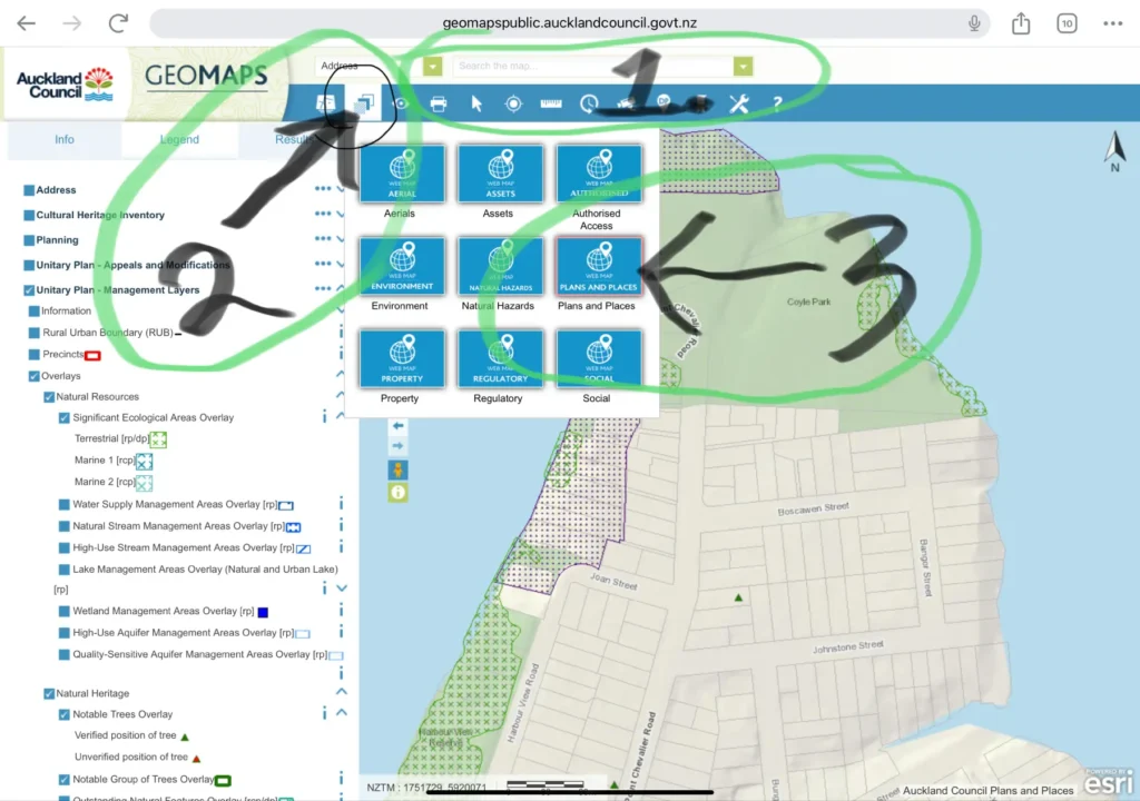
C) Follow the instructions on the photo below.
1. Put in your address and search.
2. Click on the ‘layers’ button on the top menu.
3. Click on the ‘Plans and Places’ option.
D) As shown in these next screenshots, you can now scroll down the list and select the tick boxes to see these different overlays for your chosen address on the map. It’s worth noting that the structure of the tick box options and sub categories may require you to expand the parent category by clicking on the little arrow to the right of each click box option, then selecting the specific ‘layer’ in order for you to see the intended detail.
The little pictures next to your selected options are the map legend, which help you to see where everything is. If you don’t see anything over your selected property, and want to double check it, you can always zoom out, or try a different address.
Yes, it’s clunky. I’m sure if you used it every day you’d get used to it, but for now let’s make this easy for you!
You can now view the specific layers mentioned above, by following this process
i) For Significant Ecological Areas (SEA) info (green), click on: Unitary Plan -> Management Layers -> Overlays -> Natural Resources -> Significant Ecological Area Overlay.
ii) For Notable Trees info (blue), click on: Unitary Plan -> Management Layers -> Overlays -> Natural Heritage -> Notable Trees Overlay
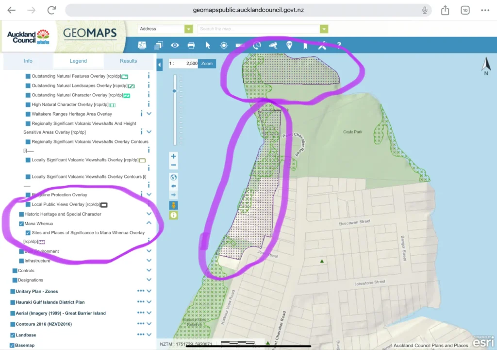
iii) For Mana Whenua Areas (purple), click on: Unitary Plan -> Management Layers -> Overlays -> Mana Whenua-> Sites and Places of Significance to Mana Whenua Overlay
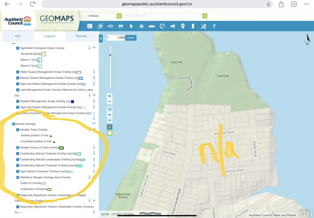
iv) For groupings of Notable trees info (yellow), click on: Unitary Plan -> Management Layers -> Overlays -> Natural Heritage -> Notable Group of Trees Overlay
v) For Waitākere Ranges Heritage Area info (yellow), click on: Unitary Plan – Management Layers -> Overlays -> Natural Heritage -> Waitākere Ranges Heritage Area Overlay
*Please note that both iv) and v) in yellow, are not showing on the example map. This is because there are no examples of either groupings of notable trees, nor Waitākere Ranges Heritage Areas at the end of the Point Chevalier peninsula.
It’s best to be safe and respectful.
It’s worth checking with the council first, before you sharpen your saw. Any work undertaken that fits into these categories puts you at risk of hefty fines or being put in the naughty corner. This guide is written for you as a guideline, but it isn’t gospel – and the Auckland Council is ultimately the deity that we need to follow. There are always unique and specific considerations for every tree on every property, so best to be proactive, plan ahead and follow the correct process. Sometimes that correct process will involve getting resource consent first.
If all of this sounds like a bit too much, there’s also a super simple option for you: Give us a yell, and let us take care of it for you, while you get back to being awesome.
Thanks for reading,
Colossal Trees team.
Considerate. Done.